Reference
How to look up Ontario’s water well records
Where the records live, how to read one, and the one thing they cannot tell you · Last updated 2026-08-17
A rural property comes with a water system, and most buyers price it at zero. The house gets inspected, the water gets a glance, and the first hard information arrives after closing, sometimes in the first dry August. It does not have to happen in that order. Ontario has been collecting well drillers’ reports for decades, and the file on the ground under a property is thicker than most people expect.
What is in the records
When a licensed contractor drills a well in Ontario, a record goes to the province. The water well records database holds well over a million of them, and each one is a small technical diary of a single hole: where it was drilled, when, how deep, what the drill passed through on the way down, where water was found, and the rate the well produced when it was tested at completion.
Read together, the records near a property sketch the neighbourhood’s water. If the six recorded wells around a lot were drilled between 24 and 40 metres and all found water in the same fractured rock, that is a real clue about what a new well there would involve. If half of them are 9-metre dug wells from the 1970s, that is a different clue. Three other public records fill out the picture:
- Permits to take water. Anyone taking more than a threshold amount per day, such as a golf course, a bottler or a municipal wellfield, needs a permit, and permits are public. A large permitted taking near a property is worth knowing about before it is your aquifer too.
- Source protection areas. Where a municipal drinking water supply draws from, the province maps protection zones that can restrict certain activities on the land inside them.
- Groundwater monitoring. A provincial network of monitoring wells tracks water levels over time, which is the closest thing to a public record of how the water table behaves through dry years.
Where to find them, free
The records are public and cost nothing to look at. The Ministry of the Environment, Conservation and Parks publishes them two ways:
- The province’s well records map (ontario.ca, “Map: Well records”). Zoom to the property, and recorded wells appear as points you can click for the record behind each one. This is the right tool for looking at one neighbourhood.
- The full dataset (data.ontario.ca, “Well Records”), for anyone who wants the raw files. The records run from 1899 to the present and are refreshed twice a year, so a well drilled last spring may not have reached the file yet.
Two things to expect when you open the map. First, the pins are approximate: well locations were recorded with whatever precision the driller supplied, and a pin can sit a lot-width or more from the wellhead it describes. Second, the record itself is a form filled in by a busy contractor, in the vocabulary of the trade. It rewards knowing what the fields mean, which is the next section.
How to read a well record
Most of what a record can tell you sits in a handful of fields. In plain language:
- Date completed. When the well was finished. Everything else in the record was true on this day, and the further back it is, the more loosely it describes the well today.
- Final status. What the hole became: a water supply, a test hole, a monitoring well, or an abandoned or plugged well. Only “water supply” records describe a well someone drank from.
- Total depth. How far down the drill stopped. The neighbourhood’s range matters more than any single number: six wells between 24 and 40 metres tell a consistent story about the ground; one at 8 and one at 140 tell you the ground varies, and budgeting a new well there is a gamble.
- Depth to bedrock. Where loose ground (sand, clay, gravel) ends and rock begins. On the Canadian Shield that is often within a few metres of the surface, and most of the hole is through rock.
- Water found. The depth at which the driller struck water. There can be more than one entry, one per water-bearing zone.
- Static level. Where the water settled in the finished well, measured from the surface. Water struck at 60 metres will often stand at 6, because it rises under its own pressure once the hole reaches it. A shallow static level is what the pump actually lifts from, which is why this field matters as much as depth.
- The geology log. Layer by layer, what the drill passed through, in the driller’s shorthand: “GREY LMSN” is grey limestone, “GRNT” granite, “SNDS” sandstone. Read down the column and you are reading a core sample of the neighbourhood in text form.
- Yield and pump test. The rate the well produced when tested at completion, usually in gallons per minute. A 1998 test is a 1998 fact; treat it as history, not a promise.
What the records look like read together
Here is that reading applied. This is the well page from a LastLake report on one of our inland test properties on Lake Muskoka: every working water supply on record within a kilometre of the property point, drawn as a column at its own depth, nearest well first.
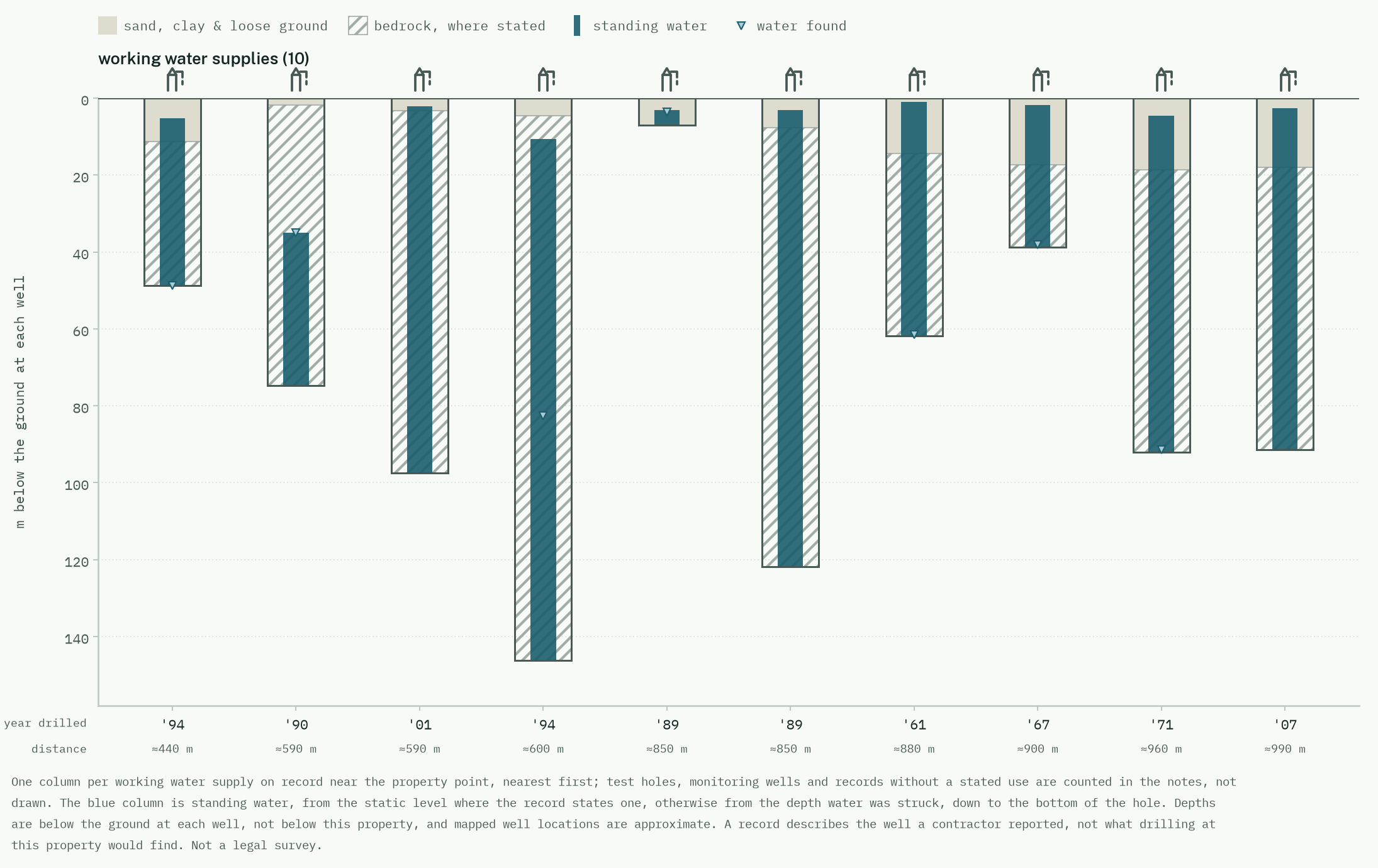
Read it the way the last section taught. The columns run from a well that stopped about eight metres down to holes that passed 140, drilled between 1961 and 2007, which says this is ground where the water does not sit at one tidy depth. The hatching is bedrock where the record states it, and in most of these wells it starts within the first several metres, so nearly all of the drilling was through rock. The blue column is standing water: in well after well it reaches to within a few metres of the surface, far above the depth where water was struck, which is the static-level story from the list above playing out across a whole neighbourhood. That is the kind of sentence a stack of individual records will not volunteer, and it is exactly the reading this page has been teaching you to do yourself.
What the records cannot tell you
Every number in a well record was true on the day the driller wrote it down. A yield tested in 1998 says nothing certain about the same well this summer. Pumps age, casings corrode, water tables move, and none of that flows back into the record.
The records are also incomplete in a particular direction: old wells. Dug wells from before reporting, and wells that were never properly recorded, exist all over rural Ontario. A property with no well record is not a property with no well, and buyers have inherited unrecorded wells, and unrecorded septic beds beside them, often enough that the gap deserves respect.
And the biggest limit is the plain one. No record in any database says whether the well serving this property produces enough water, or whether that water is safe to drink, today. Those are the two halves of the well test: a flow test on the pump and a water sample to a lab. Public health units supply sample bottles, often free. Lenders sometimes require the test anyway. Nothing on this page or in any report substitutes for it.
The questions that settle it, and who answers them
To the seller: “May I have the well record for this well, and a recent water test?” To your own side: book the flow test and the lab sample as a condition, not as a task for after closing.
A seller who has the well record and a test from last summer just answered most of the question. A seller who has neither has not done anything wrong, since plenty of good wells run for decades on benign neglect, but the finding out has just become yours, and it is cheap while an offer is still conditional. Owners can run the same two steps any year they like, and the health unit would rather you did.
Where a report fits
A LastLake report reads the public water records around one property: the recorded wells nearby with their depths, dates and what the drillers logged, any large permitted water takings in the area, and whether the property sits in a mapped source protection zone. It gives the well conversation its facts. It cannot test the well, and it says so on the page where the records appear.
Get the report