Parry Sound District, Ontario
Sand Lake
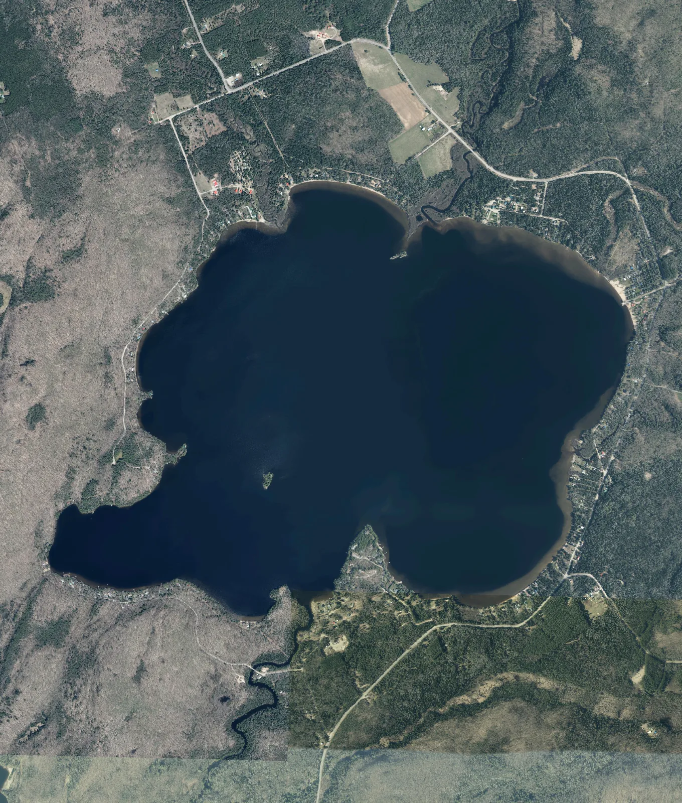
- Surface
- 5.8 km²
- Shoreline
- 13 km12 mainland + 1 island shore
- Islands
- 2
- Max depth
- 50.1 m
- Soundings
- 1,167
Where Sand Lake is
Sand Lake lies in the District of Parry Sound, within the Town of Kearney.
How deep is Sand Lake?
Sand Lake reaches a maximum recorded depth of 50.1 meters, determined from 1,167 soundings.
See also Ontario's Largest and Deepest Lakes
Surveyed Depths
Ontario has surveyed the depths of several thousand of its lakes over more than half a century. Later surveys were conducted by boat with satellite positioning and produced hundreds of thousands of soundings per lake. Earlier surveys were charted by running transects across the water and drawing depth contours by hand.
Water quality
Ontario’s Lake Partner Program is a volunteer monitoring network. Participants collect water samples for phosphorus analysis and measure water clarity through the summer with a Secchi disk. Most sites are sampled for phosphorus once a year, in spring, and some several times a year between spring and fall. Phosphorus in many lakes rises through the summer, so the two kinds of average are measured on different bases.
Phosphorus is the nutrient that controls how much algae a lake can grow. A lake with little phosphorus stays clear and supports cold-water fish such as lake trout. As phosphorus rises, algae increase, the water clouds, and oxygen in the deep water falls as the algae decay. The province classifies each monitoring site by its average phosphorus:
- Oligotrophic, below 10 micrograms per litre: clear water and low algae.
- Mesotrophic, from 10 to 20: moderately productive water, with more algae and weed growth than an oligotrophic lake but rarely a bloom.
- Eutrophic, above 20: nutrient-rich water, prone to algal blooms and low oxygen at depth.
Sand Lake has 2 Lake Partner monitoring sites. One of them has reported phosphorus for the three or more years the province requires before a status is assigned, and is classified oligotrophic.
| Site | Location | Years | Samples a year | Last sampled | Classification |
|---|---|---|---|---|---|
| 4776/1 | Deep spot | 22 | 1 | 2025 | oligotrophic |
The longest record is held by site 4776/1 at Deep spot, with phosphorus sampled once a year over 22 years to 2025. Its long-term mean phosphorus concentration is 6.64 micrograms per litre, within the oligotrophic band, which extends to 10.
A Secchi disk is a white or black-and-white plate lowered on a marked line until it disappears from view. The depth at which it vanishes is the Secchi depth, a direct measure of water clarity. Clearer water gives a deeper reading.
The 232 clarity readings at site 4776/1 give a median Secchi depth of 4.5 meters.
Median Secchi depth by year at site 4776/1
- Median Secchi depth
- Shallowest to deepest reading
Sand Lake Weather
The weather page for Sand Lake carries the forecast over the water, wave heights across the lake, and the modelled water temperature.
Water temperature
Ontario’s aquatic resource records class Sand Lake as a cold-water lake, with a mean depth of 22 meters against its maximum of 50.1.
A deep lake separates into layers through the summer. Sunlight and wind warm and mix the upper few meters, and beneath a band of rapid cooling, the thermocline, the water stays cold through the whole season. A mean depth of 22 meters places most of Sand Lake’s volume in that cold layer, which is the condition lake trout and lake whitefish require.
No provincial monitoring station records water temperature on Sand Lake. The weather page for Sand Lake carries the LastLake model’s surface water temperature for each day of the coming week. The province’s longest in-water record is kept on eight research lakes near Dorset, sampled since 1976. A reading is taken at the surface, at one meter, at each meter to seven and then every two meters to the bottom, about every two weeks through the open-water season and about monthly under ice. The record holds 5,240 readings at a depth of one meter.
At one meter the eight lakes track one another closely. On a day when several were sampled, the warmest and the coolest lake differed by about one degree in every month of the year, and a 12 meter deep lake and a 37 meter deep lake read within 0.2 degrees of each other from June to October. The weather of the year, and not the lake, sets most of the width of the band below.
Water temperature at a depth of one meter (eight lakes near Dorset, ON)
How depth changes the temperature
The chart below is the province’s record on Harp Lake, 37 meters deep, drawn as the median temperature at each depth for each month over 49 years. In July the water at one meter is 23 degrees, at five meters 15, at seven meters 9, and from 13 meters to the bottom under 6. By October the warm layer has deepened to seven meters and cooled to 11 degrees. In February the whole column sits between 1 and 4 degrees under the ice, coldest at the top.
- February, under ice
- May
- June
- July
- August
- September
- October
A shallower lake in the same record warms sooner. Heney Lake, six meters deep, reads about 1.8 degrees warmer than Harp Lake at one meter from January to May, 0.8 degrees warmer from June to August, and the same or cooler from September.
See also Lake Water Temperature in Ontario
Fish in Sand Lake
Ontario’s aquatic resource records name 12 fish species in Sand Lake. The province’s other records for the lake name two further species, brook trout and splake. They appear in the records below.
Popular species in the province’s records
 Lake Trouttrout and whitefish
 Rainbow Trouttrout and whitefish
 Lake Whitefishtrout and whitefish
 Ciscotrout and whitefish
 Northern Pikepike
 Yellow Perchperch
 Smallmouth Basssunfish
 Largemouth Basssunfish
 Rock Basssunfish
 Burbotcod
| Family | Species |
|---|---|
| Trout and whitefish | brook trout, splake |
| Sucker | white sucker |
| Smelt | rainbow smelt |
Spawning areas
Ontario maps 5 fish spawning records within the Sand Lake outline, for three different species, and all of them are mapped below. Every record is recorded as verified and presently suitable, and none is classed as sensitive.
By number of records
By area mapped
- Lake Trout3 areas0.3 ha
- Lake Whitefish1 area0.3 ha
- Rainbow Trout1 area0.1 ha
The federal Fisheries Act prohibits the harmful alteration, disruption or destruction of fish habitat without an authorization, so a dock, dredging, infill or shoreline work at a mapped spawning area is reviewed on that basis.
Stocking history
Ontario’s stocking records for Sand Lake run from 1946 to 2015 and hold 70 releases. Lake Trout account for most of the fish: 129,972 released in 35 of the years between 1947 and 2015. The last recorded release was 1,000 lake trout yearlings in 2015.
| Species | Years | Years with a release | Fish released |
|---|---|---|---|
| Lake Trout | 1947 to 2015 | 35 | 129,972 |
| Rainbow Trout | 1950 to 1989 | 19 | 59,050 |
| Brook Trout | 1946 to 1958 | 11 | 28,700 |
| Splake | 1999 | 1 | 2,500 |
| Lake TroutRecreational stocking record | 2017 to 2025 | 5 | 3,700 |
Eating the fish
The 2026 Guide to Eating Ontario Fish carries consumption advice for four species taken from Sand Lake, tested for contaminants at a sampling location in Proudfoot Twp., Parry Sound Dist. Each figure below is the most meals a month the guide advises for a fish of that length. Where mercury sets the advice, the figure falls as the fish gets longer, because mercury accumulates over a fish’s life. A zero means the guide advises no meals of that fish at that size.
General population: adultsSensitive population: children under fifteen, women who are or may become pregnant
| Length, cm | 25 to 30 | 30 to 35 | 35 to 40 | 40 to 45 | 45 to 50 | 50 to 55 | 55 to 60 | 60 to 65 | 65 to 70 | 70 to 75 |
|---|---|---|---|---|---|---|---|---|---|---|
| General population | 8 | 8 | 4 | 4 | 4 | 4 | 4 | 2 | 0 | 0 |
| Sensitive population | 4 | 0 | 0 | 0 | 0 | 0 | 0 | 0 | 0 | 0 |
| Length, cm | 55 to 60 | 60 to 65 |
|---|---|---|
| General population | 4 | 2 |
| Sensitive population | 0 | 0 |
| Length, cm | 40 to 45 | 45 to 50 | 50 to 55 | 55 to 60 | 60 to 65 |
|---|---|---|---|---|---|
| General population | 4 | 4 | 4 | 4 | 4 |
| Sensitive population | 0 | 0 | 0 | 0 | 0 |
| Length, cm | 30 to 35 | 35 to 40 | 40 to 45 | 45 to 50 |
|---|---|---|---|---|
| General population | 16 | 16 | 12 | 8 |
| Sensitive population | 8 | 8 | 4 | 4 |
Fisheries Management Zone 15
Sand Lake lies in Fisheries Management Zone 15. Ontario sets its fishing seasons and catch limits by zone. The province describes it as a zone of many natural lake trout and brook trout lakes, with a well-developed road network and moderate angling effort.
Fisheries management zones around Sand Lake
| Species | Open season | Sport licence | Conservation licence |
|---|---|---|---|
| Brook Trout | Jan. 1 – Sept. 30 | 5 | 2 |
| Brown Trout | Open all year | 5 | 2 |
| Channel Catfish | Open all year | 12 | 6 |
| Crappie | Open all year | 30 | 10 |
| Lake Trout | Jan. 1 – Sept. 30 | 2 | 1 |
| Lake Whitefish | Open all year | 12 | 6 |
| Largemouth and Smallmouth Bass or any combination | 4th Sat. in June – Nov. 30 | 6 | 2 |
| Muskellunge | 1st Sat. in June – Dec. 15 | 1, must be greater than 91 cm (36 in.) | 0 |
| Northern Pike | Jan. 1 – Mar. 31 & 3rd Sat. in May – Dec. 31 | 6 | 2 |
| Pacific Salmon | Open all year | 5 | 2 |
| Rainbow Trout | Open all year | 5 | 2 |
| Splake | Open all year | 5 | 2 |
| Sunfish | Open all year | 50 | 25 |
| Walleye and Sauger or any combination | Jan. 1 – Mar. 15 & 3rd Sat. in May – Dec. 31 | 4, not more than 1 greater than 46 cm (18.1 in.) | 2, not more than 1 greater than 46 cm (18.1 in.) |
| Yellow Perch | Open all year | 50 | 25 |
| Where | Closed |
|---|---|
| Cashman Creek – from the first bridge upstream from Sand Lake to the Proudfoot/Bethune Twp. boundary | No fishing from Apr. 1 – May 31 |
See also Fishing Seasons in Ontario, Zone by Zone and Fish Stocking in Ontario Lakes
Sand Lake Ice Fishing
An ice hut on Sand Lake must be removed by March 31. The province sets dates for ice hut removal as a safety measure to ensure huts are removed before thawing occurs. One date applies to an entire fisheries management zone (FMZ). Sand Lake lies within FMZ 15.
An ice hut must also be removed before the ice breaks up, whether or not that date has passed. The deadline clears huts from the ice ahead of the thaw and does not close the fishing season.
Registration is required in FMZ 15 for an ice hut built of anything other than fabric, and for a fabric tent covering seven square meters or more. Registration is free, and the number is displayed on the outside of the hut.
Ice In / Out Date
No ice record is kept on Sand Lake. The province’s nearest long record covers eight lakes near Dorset, about 47 kilometers away. It holds a date for every winter since 1975, observed by eye and from cameras set on the shore.
On those eight lakes the median date of complete ice cover is December 7 and the median date of complete ice loss is April 20, a median season of 134 days.
The date the ice forms has moved later through the record: a November 26 average across 1971 to 1980, and December 11 across 2011 to 2020. The date it leaves has moved by less than a day each decade over the same period. The two charts below are drawn to one scale of 26 days, so they can be read against each other.
Ice in date (eight lakes near Dorset, ON)
Ice out date (eight lakes near Dorset, ON)
Ice conditions
No public record reports the thickness or the condition of the ice on Sand Lake on any given day. Ontario publishes ice safety guidance for anyone going out on the ice, at ontario.ca.
See also Lake Ice in Ontario and When the Lakes Will Freeze This Winter
Islands and names
Sand Lake contains two islands in the Ontario Hydro Network’s outline, of 0.3 and 0.2 hectares.
Official names
Ontario’s geographic names register lists 2 official names on the water and its islands: 2 islands.
Nearby lakes
- Three Mile Lake12 km away
- Pickerel Lake12 km away
- Bay Lake14 km away
- Clear Lake15 km away
Questions about Sand Lake
- How deep is Sand Lake?
Its maximum recorded depth is 50.1 meters.
- How big is Sand Lake?
Its surface covers 5.8 square kilometers and it holds 2 islands. Of its 13 kilometers of shoreline, 12 kilometers is the mainland shore and 1 kilometer is the shore of the islands.
- What fish are in Sand Lake?
Ontario’s aquatic resource records name twelve species, among them lake trout, smallmouth bass, largemouth bass, northern pike, lake whitefish and yellow perch. The lake’s spawning, consumption and stocking records also name brook trout and splake.
- Is the water clear?
The one monitoring site with a phosphorus status is classified oligotrophic, the clearest of the province’s three bands.
Lake guides
- Lake Ice in Ontario
- Lake Water Levels in Ontario
- Lake Water Temperature in Ontario
- Fishing Seasons in Ontario, Zone by Zone
- Fish Stocking in Ontario Lakes
- Ontario's Largest and Deepest Lakes
- Lake Water Quality and Blue-Green Algae in Ontario
- Boat Launches on Ontario Lakes
- When the Lakes Will Freeze This Winter
Looking at a property on Sand Lake?
Depth and water quality are two records out of many. Our Rural & Cottage Buyer’s Report gathers what the public record holds about one specific address: shore road allowance, road access, wells, flood mapping, Crown land, wetlands and more, read and checked by a person before it is sent.
Where these figures come from
- Depth, shoreline, islands and named places: Ontario Ministry of Natural Resources bathymetry and the Ontario Hydro Network, © King’s Printer for Ontario, Open Government Licence – Ontario.
- Phosphorus and water clarity: Ontario Lake Partner Program, Ministry of the Environment, Conservation and Parks, Open Government Licence – Ontario. Extract built 2026-10-06.
- Aerial photography: Ontario Imagery Web Map Service, © King’s Printer for Ontario, Open Government Licence – Ontario, drawing this frame from South Central Ontario Orthophotography 2023, Central Ontario Orthophotography Project 2021 and Sentinel 2 2025, satellite.
- Official names: Geographic Names Ontario, Ministry of Natural Resources, Open Government Licence – Ontario.
- Lake outline and municipal boundaries: Ontario Hydro Network and Ontario municipal boundary records, Ministry of Natural Resources, Open Government Licence – Ontario.
- Water temperature: Inland Lakes and Streams, Physical Conditions, Dorset Environmental Science Centre, Ministry of the Environment, Conservation and Parks, Open Government Licence – Ontario, 1976 to 2025.
- Surface water temperature: LastLake model, on the daily air temperatures of Environment and Climate Change Canada’s climate stations and its forecast. Data Source: Environment and Climate Change Canada.
- Fish species and thermal regime: Ontario Aquatic Resource Area records. Spawning areas: Ontario Fish Activity Area records. Both Ministry of Natural Resources, Open Government Licence – Ontario.
- Stocking: Historical Fish Stocking Data and Fish Stocking Data for Recreational Purposes, Ministry of Natural Resources, Open Government Licence – Ontario.
- Consumption advice: Guide to Eating Ontario Fish advisory database, 2026 edition, Ministry of the Environment, Conservation and Parks, Open Government Licence – Ontario.
- Seasons and limits: Ontario recreational fishing regulations data, Ministry of Natural Resources, Open Government Licence – Ontario.
- Zone boundaries: Fisheries Management Zone, Ministry of Natural Resources, Open Government Licence – Ontario.
- Fish plates: Duane Raver, U.S. Fish and Wildlife Service; Ellen Edmonson and Hugh Chrisp, New York State Conservation Department; Timothy Knepp, U.S. Fish and Wildlife Service; U.S. Fish and Wildlife Service. All public domain.
- Ice dates near Dorset: Inland Lakes and Streams, Physical Conditions, Dorset Environmental Science Centre, Ministry of the Environment, Conservation and Parks, Open Government Licence – Ontario, 1974 to 2022.
- Ice hut removal dates and registration: Ontario fishing regulations, read September 2026.